
See how those crazy Dutch build all kind things in the Sea.
Sand engine
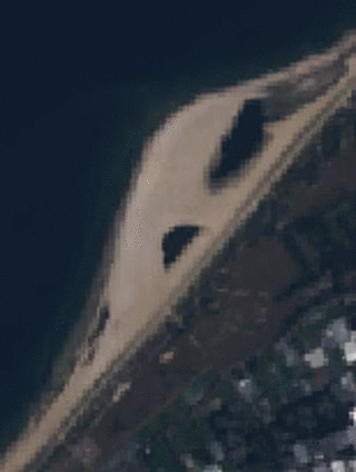
The sand engine (also called Sand Motor) is an experiment in the management of dynamic coastline. It is run off South Holland in the Netherlands. A sandbar-shaped peninsula was created by man; the surface is about 1 km². It is expected that this sand is then moved over the years by the action of waves, wind and currents along the coast. To protect the West of the Netherlands against the sea, the beaches along the coast are artificially replenished every five years, and it is expected that the sand engine will make replenishment along the Delfland Coast unnecessary for the next 20 years. This method is expected to be more cost effective and also helps nature by reducing the repeated disruption caused by dredging and replenishment.
We use Landsat 8 to create a movie in the Google Earth Engine
Step 1: import the landsat 8 image collection.
Step 2: Create a polygon.
Step 3: use the script below to select all cloudfree images.
// select all landsat 8 images at this specific location
var allimages = l8.filterBounds(geometry)
                  .sort('system:time_start',true)

// print metadata
print(allimages);

// set cloud threshold (1%)
var value = 1;

// filter based on location and cloudcover
var nocloudimages =  l8.filterBounds(geometry)
                     .filter(ee.Filter.lt('CLOUD_COVER', value))
                     .sort('system:time_start', true)

// print metadata
print(nocloudimages);

// all images to a list
var nocloudlist = nocloudimages.toList(500);

// add the first image of the list
Map.addLayer(ee.Image(nocloudlist.get(1)),{bands: ['B3', 'B2', 'B1'], max: 0.3},"image 1");

// number of images in list
var mylength = nocloudlist.length();

// add the first image of the list
Map.addLayer(ee.Image(nocloudlist.get(ee.Number(mylength).subtract(1))),{bands: ['B3', 'B2', 'B1'], max: 0.3},"last image");

// centerobject to location
Map.centerObject(geometry,10)

// lets make it a movie for fun

// select the RGB bands
var nocloud3bands = nocloudimages.select(['B3', 'B2', 'B1'])

var coll4Video = nocloud3bands
  .map(function(image) {
    return image.multiply(512).uint8();   // need to make it 8-bit
  });

Export.video.toDrive({
    collection: coll4Video,
    description: "SandEngine" ,
    scale: 30,
    framesPerSecond: 0.5,
    region: geometry
});

See an example here.
Maasvlakte 2
Maasvlakte 2 is a major civil engineering project in the Netherlands, constructing a new port and supporting infrastructure on reclaimed land adjoining the Maasvlakte. Approximately 2000 hectares is reclaimed, behind a 4 km dike; approximately 1000 hectares will be used by ports related industries. It is an extension of the Port of Rotterdam.
We use landsat 5 in this example. Follow step 1 and 2 above. Use this example.

