
Flatten the topography
Add a geometry and use the code below or click here.
var dem = ee.Image("USGS/SRTMGL1_003")
var S2 = ee.ImageCollection("COPERNICUS/S2");
var img = ee.Image(S2.filterBounds(geometry).sort("CLOUD_COVERAGE_ASSESSMENT").first())
.select(['B2','B3','B4','B8','B11','B12'], ['BLUE', 'GREEN', 'RED', 'NIR', 'SWIR1', 'SWIR2']) ;
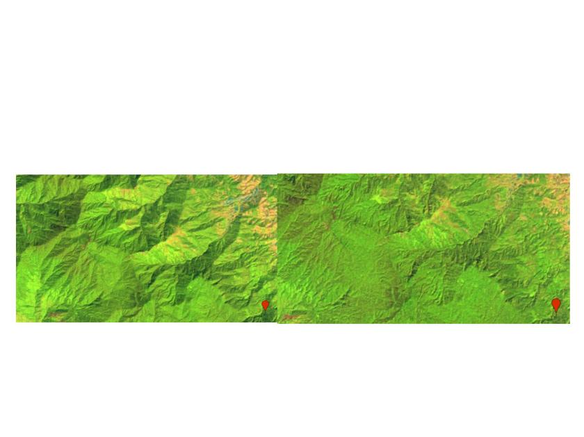
Map.addLayer(img,{min:0,max:3000,bands:"SWIR1,NIR,RED"},"original");
Map.addLayer(img,{min:0,max:3000,bands:"SWIR1,NIR,RED"},"false color");
img = topoCorr_IC_L4toL8(img);
img = topoCorr_SCSc_L4toL8(img);
function topoCorr_IC_L4toL8(img){
// Extract image metadata about solar position
var SZ_rad = ee.Image.constant(ee.Number(img.get('MEAN_SOLAR_ZENITH_ANGLE'))).multiply(3.14159265359).divide(180).clip(img.geometry().buffer(10000));
var SA_rad = ee.Image.constant(ee.Number(img.get('MEAN_SOLAR_AZIMUTH_ANGLE')).multiply(3.14159265359).divide(180)).clip(img.geometry().buffer(10000));
// Creat terrain layers
var slp = ee.Terrain.slope(dem).clip(img.geometry().buffer(10000));
var slp_rad = ee.Terrain.slope(dem).multiply(3.14159265359).divide(180).clip(img.geometry().buffer(10000));
var asp_rad = ee.Terrain.aspect(dem).multiply(3.14159265359).divide(180).clip(img.geometry().buffer(10000));
// Calculate the Illumination Condition (IC)
// slope part of the illumination condition
var cosZ = SZ_rad.cos();
var cosS = slp_rad.cos();
var slope_illumination = cosS.expression("cosZ * cosS",
{'cosZ': cosZ,
'cosS': cosS.select('slope')});
// aspect part of the illumination condition
var sinZ = SZ_rad.sin();
var sinS = slp_rad.sin();
var cosAziDiff = (SA_rad.subtract(asp_rad)).cos();
var aspect_illumination = sinZ.expression("sinZ * sinS * cosAziDiff",
{'sinZ': sinZ,
'sinS': sinS,
'cosAziDiff': cosAziDiff});
// full illumination condition (IC)
var ic = slope_illumination.add(aspect_illumination);
// Add IC to original image
var img_plus_ic = ee.Image(img.addBands(ic.rename('IC')).addBands(cosZ.rename('cosZ')).addBands(cosS.rename('cosS')).addBands(slp.rename('slope')));
return img_plus_ic;
}
function topoCorr_SCSc_L4toL8(img){
var img_plus_ic = img;
var mask1 = img_plus_ic.select('NIR').gt(-0.1);
var mask2 = img_plus_ic.select('slope').gte(5)
.and(img_plus_ic.select('IC').gte(0))
.and(img_plus_ic.select('NIR').gt(-0.1));
var img_plus_ic_mask2 = ee.Image(img_plus_ic.updateMask(mask2));
var bandList = ['BLUE', 'GREEN', 'RED', 'NIR', 'SWIR1', 'SWIR2']; // Specify Bands to topographically correct
function apply_SCSccorr(bandList){
var method = 'SCSc';
var out = img_plus_ic_mask2.select('IC', bandList).reduceRegion({
reducer: ee.Reducer.linearFit(), // Compute coefficients: a(slope), b(offset), c(b/a)
geometry: ee.Geometry(img.geometry().buffer(-5000)), // trim off the outer edges of the image for linear relationship
scale: 10,
maxPixels: 1000000000
});
var out_a = ee.Number(out.get('scale'));
var out_b = ee.Number(out.get('offset'));
var out_c = ee.Number(out.get('offset')).divide(ee.Number(out.get('scale')));
//apply the SCSc correction
var SCSc_output = img_plus_ic_mask2.expression("((image * (cosB * cosZ + cvalue)) / (ic + cvalue))", {
'image': img_plus_ic_mask2.select(bandList),
'ic': img_plus_ic_mask2.select('IC'),
'cosB': img_plus_ic_mask2.select('cosS'),
'cosZ': img_plus_ic_mask2.select('cosZ'),
'cvalue': out_c
});
return ee.Image(SCSc_output);
}
var img_SCSccorr = ee.Image(bandList.map(apply_SCSccorr)).addBands(img_plus_ic.select('IC'));
var bandList_IC = ee.List([bandList, 'IC']).flatten();
return img_SCSccorr.unmask(img_plus_ic.select(bandList_IC))
.addBands(mask1.rename('initMask'))
.addBands(mask2.rename('corrMask'));
}

Hi, thanks for all your examples! I’m working with a map in Australia using Landsat level 1 Surface Reflectance data, I’m not sure if I need to perform the terrain correction or not. If yes, how to do preserve the properties of the images (e.g. MEAN_SOLAR_ZENITH_ANGLE) after using a reducer. In my case I’m taking the median of all the images in a 5 year period. However, the resulting image only contains the bands not the properties. Any help would be great.
Thanks,
Marco
LikeLike
you can copy the properties of your input and write it to your output img. use copyproperties
LikeLike
Hello, thanks for the code! Is there a literature reference for the algorithms for topographic correction that you used?
LikeLike
Hello, Thank you so much. I would like to export the output image (to an asset), but I could not find the way to do it.
LikeLike