
The Burned Area Index
The Burned Area Index (BAI) was developed by Chuvieco et al. (2002) to assist in the delineation of burn scars and assessment of burn severity. It is based on the spectral distance to charcoal reflectance.
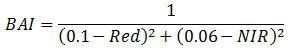
The script below shows the BAI for Portugal using Landsat-8
<span id="mce_SELREST_start" style="overflow:hidden;line-height:0"></span>
// setup Visualization
var viz = {min:0.0, max:400.0, palette:['green', 'blue', 'yellow', 'red']};
// Data
// get landsat 8 image
var image = ee.Image("LANDSAT/LC08/C01/T1_RT_TOA/LC08_204032_20170802");
// Functions
// calculate BAI
var bai = image.expression(
'1.0 / ((0.1 - RED)**2 + (0.06 - NIR)**2)', {
'NIR': image.select('B5'),
'RED': image.select('B4'),
});
// Add to map
Map.addLayer(bai,viz,"Wildfire portugal");
Map.centerObject(bai,7);
